Cape Tribulation sits at the far end of a road that most visitors to Far North Queensland never finish. It is the point where the Daintree rainforest stops being a backdrop and becomes the last thing between you and the sand, and where the Great Barrier Reef is close enough to reach by a short boat ride from the beach itself. Nothing else about the name is subtle, and neither is the place.
Where the Rainforest Runs Out of Land
Most of the Queensland coast keeps its rainforest and its reef at arm’s length from each other — hills, farmland, towns and highway in between. At Cape Tribulation, that gap closes to almost nothing. Fan palms and strangler figs lean over the high-tide line at Myall Beach, cassowaries and tree kangaroos live within a few hundred metres of the water, and the outer reef lies not much further offshore than it does at Cairns or Port Douglas. This is the geography that gives Cape Tribulation its reputation, and it is worth understanding before you plan the trip, because it also explains most of the rules that follow: the ferry, the safety warnings, and the reason the road stops being a road just past here.
Captain Cook and the Naming of Cape Tribulation
The name is not scenery marketing. On 10 June 1770, James Cook’s ship Endeavour struck a coral reef off this stretch of coast while charting the Australian east coast, tearing a hole in the hull that nearly sank the ship. Cook is said to have named the headland Cape Tribulation because, in his words, “here began all our troubles.” The ship was eventually beached and repaired further north, near what is now Cooktown, after weeks of emergency work. It is one of the few places in Australia where the origin story of the name is also a fairly accurate description of what the coastline still does to the unprepared: it looks calm, and it is not to be underestimated.
Two World Heritage Areas, One Beach
This is the fact that makes Cape Tribulation more than a pretty stop on the way north. The Great Barrier Reef was added to the UNESCO World Heritage List in 1981, recognised as the largest living structure on the planet. The Wet Tropics of Queensland — the rainforest belt that runs from around Townsville up through the Atherton Tablelands and the Daintree — followed in 1988, protecting some of the oldest continuously surviving rainforest on Earth, older than the Amazon.
Almost everywhere along this coast, the two World Heritage areas sit near each other but not touching. At Cape Tribulation, they do touch: the rainforest grows down to the tideline, and the reef begins not far past the breakers. Cape Tribulation is, as far as anyone can establish, the only point on Earth where two World Heritage-listed natural sites meet at the water’s edge. It’s a genuinely rare coincidence of geology and geography, and it’s the reason this stretch of coast punches so far above its size on any map of Australia.
Getting to Cape Tribulation: The Daintree River Ferry
There is exactly one way to reach Cape Tribulation by road, and it is not a bridge. The Daintree River is crossed by a small cable ferry, a vehicle-carrying platform that pulls itself across the river on a cable rather than under its own power. It is a paid crossing, charged per vehicle each time you cross, and it runs from early in the morning until midnight — not around the clock. There is no free alternative, no back road, and no bridge planned; a bridge here has been debated for decades and rejected every time, partly to limit development pressure on the rainforest side of the river.
Once you’re across, the character of the trip changes. Fuel becomes scarce — there is no petrol station beyond the ferry, so fill up in Mossman or Daintree Village before you cross. Mobile phone coverage becomes unreliable to non-existent for most carriers, so don’t count on maps, ride-hailing apps or emergency calls working the way they do in town. Many properties beyond the river run on solar power.
None of this makes Cape Tribulation hard to visit — thousands of people do it every week — but it does mean planning ahead rather than assuming town-level infrastructure. For the full driving breakdown, including road conditions and what to check before you leave Cairns or Port Douglas, see the dedicated guide to driving to Cape Tribulation.
Most visitors skip the logistics altogether by joining a guided tour. A day tour bundles the drive, the ferry crossing, and a local guide who can point out wildlife you would otherwise miss:
a full-day guided tour from Cairns to Cape Tribulation covers the rainforest boardwalks, a beach stop, and usually a river cruise, without anyone in the group needing to watch the ferry schedule.
Myall Beach, Thornton Beach and Cow Bay
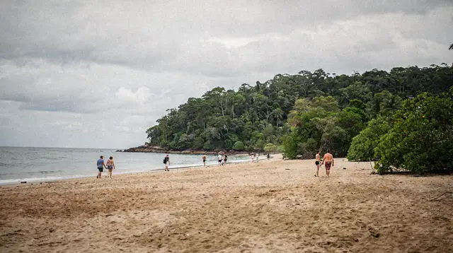
“Cape Tribulation” describes a headland, but in practice it names a scattered strip of beaches and rainforest settlements running along the coast north of the Daintree River. Myall Beach, right at the base of the cape itself, is the beach most people picture: a long curve of sand with rainforest growing almost to the high-tide mark, backed by the short Dubuji Boardwalk through mangrove and lowland forest.
Thornton Beach, a little south, is quieter and edged by exposed granite boulders, with a small kiosk nearby. Cow Bay, further south again near the ferry, is where much of the accommodation and the community itself is based, along with the turnoff to the Daintree Discovery Centre and its canopy tower and aerial walkway.
None of these beaches are set up as a Cairns-style swimming beach, and that’s worth sitting with for a moment before your first walk to the water.
Rainforest and Beach Safety: What Actually Matters Here
Two separate hazards apply to this coastline, and neither is exaggerated for effect.
Marine stingers. From roughly November to May, box jellyfish and the much smaller, harder-to-see Irukandji are present in coastal waters along this whole stretch of Queensland, Cape Tribulation included. A box jellyfish sting can be life-threatening; an Irukandji sting causes a severe pain syndrome that sends people to hospital. Stinger nets exist at some patrolled beaches further south, but Cape Tribulation’s beaches are not routinely netted or patrolled the way a town beach is, so during stinger season the safest approach is to treat ocean swimming here as something you don’t do on a whim.
Estuarine crocodiles. Every river mouth, creek, mangrove channel and stretch of tidal water along this coast, the Daintree River very much included, is potential crocodile habitat. This applies at Cape Tribulation exactly as it does at Cairns’ Trinity Inlet: you do not swim, wade or paddle in rivers, creeks or mangroves here, full stop, and you take “Crocwise” signage literally rather than as decoration. The guide to seeing crocodiles safely covers where the animals actually are and how sightseeing cruises manage the risk for you rather than around you.
Put together, this means the beach at Cape Tribulation is best treated as a place to walk, photograph and explore on foot, not a default swimming spot. If a beach or a specific safe swimming point has current signage allowing it, that’s a call to make on the day, on-site, based on that signage — not something to assume in advance from a guidebook.
After Dark: A Different Rainforest
The Daintree rainforest changes completely once the sun goes down. Tree frogs, possums, gliders, and a striking range of insects and spiders become active in a forest that looks empty and quiet during the day. A guided night walk, using red-filtered torches that don’t disturb nocturnal animals, is the single best way to understand why naturalists rate this rainforest so highly:
a small-group night walk through the Cape Tribulation rainforest typically turns up more active wildlife in ninety minutes than a full day of boardwalks does.
Cape Tribulation and the Reef, Side by Side
Because the outer reef lies close to this section of coast, some boat operators run reef trips directly out of Cape Tribulation rather than from Cairns or Port Douglas, cutting the transit time to the water dramatically:
a small-boat reef and snorkelling trip departing straight from Cape Tribulation is the clearest demonstration of the “two World Heritage areas, one trip” idea — rainforest at breakfast, reef by mid-morning, all without a long coach transfer.
For travellers who want the rainforest, the reef and Aboriginal cultural knowledge combined into a single well-organised day, tours pairing Cape Tribulation with Mossman Gorge are the most efficient way to see the whole Daintree region without staying overnight:
a combined Cape Tribulation and Mossman Gorge day tour from Cairns covers both the coastal rainforest and the freshwater gorge inland in one guided day.
The Kuku Yalanji people are the Traditional Owners of this country, from Mossman Gorge north through Cape Tribulation, and their knowledge of the plants, animals and stories of this landscape runs far deeper than any wildlife spotting a visitor can manage alone:
a full-day Kuku Yalanji cultural tour of the Daintree coast is led by Traditional Owners and covers bush tucker, bush medicine and Dreamtime stories tied directly to this stretch of country.
This page covers Cape Tribulation itself rather than the activities on offer in detail — for canopy ziplining, river cruising and other Daintree activities, see the activities in the Daintree rainforest hub, and for river-based wildlife watching specifically, the guide to Daintree River cruises.
Beyond Cape Tribulation: Where the Road Stops Being a Road
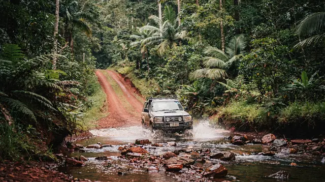
North of Cape Tribulation, the sealed road ends and the Bloomfield Track begins. This is not a scenic alternate route to Cooktown — it is an unsealed, 4WD-only track through steep, exposed terrain, and it is frequently closed or genuinely impassable during the wet season. Almost every standard rental car and campervan contract in this region explicitly excludes the Bloomfield Track from cover, which means driving it in a non-4WD hire vehicle can void your insurance entirely, on top of the practical risk of getting stuck or bogged with no phone signal.
Travellers wanting to continue on to Cooktown from here should read the dedicated Bloomfield Track 4WD guide before committing, or simply backtrack via Mossman and take the inland route instead. Cape Tribulation is a natural endpoint for most visitors, not a midpoint.
Day Trip or Overnight Stay?
A single well-planned day covers the core of Cape Tribulation: the drive up, the ferry, a couple of short rainforest walks, a beach stop, and the drive back before the ferry’s midnight cutoff. It’s the option most visitors choose, especially on a first trip to Tropical North Queensland, and it’s the easiest to combine with Mossman Gorge or Port Douglas in the same day.
Staying overnight changes the experience rather than just extending it. Cape Tribulation at dawn and dusk is measurably livelier — this is when cassowaries, pademelons and a wider range of birds are most active — and a night walk becomes a realistic addition to the day rather than a late finish tacked onto a long drive. It also removes the pressure of the ferry’s operating hours entirely.
Accommodation beyond the river ranges from simple eco-cabins to a small number of higher-end lodges, almost all run on solar power with limited connectivity. The trade-offs of staying versus day-tripping, along with what to actually expect from power, water and phone signal on the ground, are covered in full in the guide to staying overnight in the Daintree.
Best Time to Visit Cape Tribulation
| Season | Months | Conditions at Cape Tribulation |
|---|---|---|
| Dry season | May to October | Lower humidity, calmer seas, best reef visibility, no marine stingers — the recommended window |
| Wet season | November to April | Heavy, spectacular downpours, cyclone risk, marine stingers present, but the rainforest is at its lushest and prices drop |
The dry season is the straightforward recommendation for a first visit, particularly if a reef trip or rainforest walk is the priority and stinger-free swimming matters to you. The wet season is not a reason to cancel a trip already planned for those months — it’s simply a different Cape Tribulation, greener and quieter, with the understanding that a downpour can close in with very little warning and river or creek crossings elsewhere on your route may be affected. “If it’s flooded, forget it” applies here as much as anywhere else in Far North Queensland.
Budgeting a Trip to Cape Tribulation
| Item | Typical cost |
|---|---|
| Guided day tour from Cairns or Port Douglas | Roughly A$200-250 per person |
| Daintree River ferry, self-drive (per vehicle, one way) | A modest per-crossing fee, paid both directions |
| Night walk add-on | A smaller per-person fee on top of accommodation or a day tour |
| One night in eco-accommodation beyond the ferry | Varies widely by property standard |
Treat these as order-of-magnitude figures for planning, not fixed prices — tour and ferry rates change and vary by operator and season.
Cape Tribulation in a Wider Daintree and Port Douglas Trip
Cape Tribulation rarely stands alone in an itinerary. Most visitors reach it by driving north from Port Douglas along the coast, often stopping at Mossman Gorge on the way, and many treat the whole run as a single loop out of Cairns or Port Douglas rather than a dedicated multi-day trip. For a structured plan that fits Cape Tribulation, Mossman Gorge and the Daintree properly into a few days rather than rushing all of it into one, see the Port Douglas and Daintree in four days itinerary.
Cape Tribulation FAQ: Ferry Times, Safety and What to Pack
Do you need a 4WD to get to Cape Tribulation?
No. The road from Port Douglas to Cape Tribulation, including the Daintree River ferry crossing, is sealed and manageable in a standard car or rental. A 4WD is only required beyond Cape Tribulation, on the Bloomfield Track toward Cooktown.
Can you swim at Myall Beach or Cow Bay?
Ocean swimming along this coast carries two risks: marine stingers from roughly November to May, and estuarine crocodiles in and near river mouths and creeks year-round. Swim only where signage explicitly allows it, and never in a river, creek or mangrove.
Is Cape Tribulation a day trip or an overnight stay?
Both work. A guided day tour from Cairns or Port Douglas covers the highlights in one long day, but staying one or two nights lets you experience the rainforest at dawn, at dusk and after dark, when far more wildlife is active.
How much does the Daintree River ferry cost and does it run all night?
The cable ferry is paid, per vehicle, each crossing, and runs from early morning to midnight. It does not run overnight, so this is the only way in or out of Cape Tribulation by road within that window.
Is there phone signal or fuel at Cape Tribulation?
Mobile coverage is unreliable to absent beyond the Daintree River, and there is no petrol station past the ferry. Fill the tank in Mossman or before crossing, and treat online maps and payment apps as unreliable once you’re across.
Can you continue driving north from Cape Tribulation to Cooktown?
Only via the Bloomfield Track, a 4WD-only unsealed track that is frequently closed or impassable in the wet season and excluded from standard rental car and caravan insurance. It is not a normal road and should never be attempted in a two-wheel-drive vehicle.
Why is Cape Tribulation called a meeting of two World Heritage sites?
The Great Barrier Reef was inscribed on the UNESCO World Heritage List in 1981, and the Wet Tropics of Queensland, which includes the Daintree rainforest, followed in 1988. At Cape Tribulation the rainforest reaches the shoreline within sight of the reef, making it the only place on the planet where two World Heritage-listed natural areas are contiguous.