A track, not a road
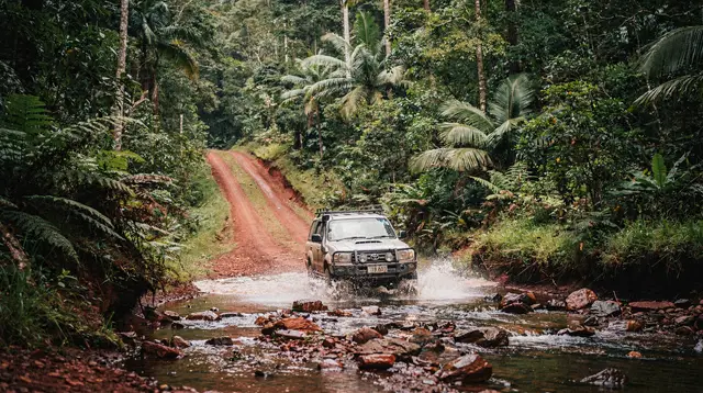
Most of the roads around Cairns eventually turn into ordinary sealed highway. The Bloomfield Track never does. North of Cape Tribulation, the bitumen simply stops, and what continues is a narrow, unsealed, high-clearance 4WD track that climbs and drops through rainforest, fords several creeks and rivers with no bridges, and eventually reaches the small community of Wujal Wujal before a sealed road resumes toward Cooktown.
There is no other way to drive this stretch of coast. If you want to go overland from Cape Tribulation to Cooktown, this is the only route, and it is a track in the full 4WD sense of the word — not a rough shortcut, not a scenic byway, and not something a standard rental sedan, SUV or campervan is built or insured to handle.
This page is about what the Bloomfield Track is, what the country either side of it looks like, and why relatively few travelers drive it themselves. For turn-by-turn advice on tackling it in your own vehicle, see our 4WD driving guide. For organised 4WD day trips that cover this ground without you needing to own or hire off-road gear, see 4WD tours from Cairns.
Where it fits on the map
The Bloomfield Track begins just north of Cape Tribulation, where the sealed Cape Tribulation road ends, and runs roughly 32 kilometres to Wujal Wujal on the Bloomfield River. From there, a sealed road continues north through Ayton and on to Cooktown, so the unsealed section is shorter than most people expect — the difficulty is concentrated, not spread thin. Counted from Cairns, the whole crossing to Cooktown covers around 220 kilometres and typically takes the best part of a day once you include the Daintree River ferry, the drive north through the rainforest, and the unsealed section itself.
| Segment | Surface | Approx. distance |
|---|---|---|
| Cairns to Daintree River ferry | Sealed | ~75 km |
| Ferry to Cape Tribulation | Sealed | ~35 km |
| Cape Tribulation to Wujal Wujal (Bloomfield Track) | Unsealed, 4WD only | ~32 km |
| Wujal Wujal to Cooktown | Sealed | ~75 km |
Once you cross the Daintree River by cable ferry, you are already off the electricity grid in any conventional sense — solar power and generators run most of what exists north of the river — and mobile coverage becomes patchy well before the Bloomfield Track even starts. By the time you reach the unsealed section itself, you should already be planning as if help is a long way off, because it is.
The landscape: rainforest that runs into the sea
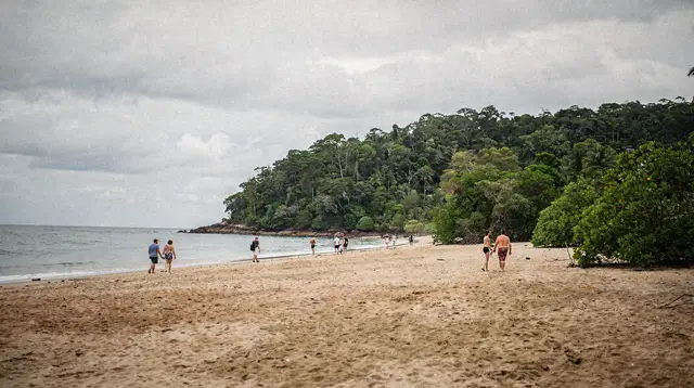
The reason this track exists at all, cut through rather than around, is the same reason the whole region is famous: here, ancient rainforest grows right down to the coastline, with no buffer of farmland, town or open ground in between. This is one of the few places on the planet where a rainforest older than flowering plants themselves meets tropical beach directly, and the Bloomfield Track drives straight through the middle of that meeting point.
Along the way, the canopy closes overhead in places thick enough to dim the middle of the day, then opens onto glimpses of the coast where the track runs close to the shoreline. Creek crossings interrupt the drive regularly — some no more than a shallow trickle over rock, others a genuine ford through moving water — and each one changes with the season and the rain of the past few days. There is no fixed answer to “how deep is it,” which is part of why this is not a route to improvise casually.
The country either side of the track sits inside the Daintree Rainforest, part of the Wet Tropics of Queensland World Heritage Area, and the vegetation here is genuinely ancient — plant lineages found nowhere else, and a canopy structure that has barely changed in geological terms. It is also cassowary country.
The southern cassowary moves through this stretch of forest, and the track passes through some of the last connected habitat this bird depends on, which is one more reason the route is treated with more caution than a typical rural back road. For what to do if you see one, see seeing crocodiles safely for the water-based equivalent caution, since the creeks and river mouths along this stretch are estuarine crocodile habitat too — you do not wade a crossing to check its depth by hand.
Cape Tribulation to the Bloomfield River
Heading north from Cape Tribulation, the sealed road gives out at a clearly signed point, and the track narrows almost immediately. The surface alternates between compacted dirt, loose rock, and — after any rain — sections of soft, deep mud that can bog an underpowered or two-wheel-drive vehicle within metres. Low-range gearing is standard practice here, not a precaution for emergencies. The gradient is steep in places, climbing over low coastal ranges before dropping back toward the river systems that eventually feed into the Bloomfield.
Several creek crossings punctuate this stretch, and their difficulty is the single biggest variable on the whole track. In a dry spell after weeks without rain, some crossings are barely a formality. After a heavy downpour — which in this part of Queensland can arrive with little warning even in the technical dry season — the same crossing can rise well above axle height within hours. Locals and tour operators check conditions daily during the shoulder months; self-drivers are expected to do the same before committing, and to turn back rather than push through a crossing that looks doubtful.
The Bloomfield River and Wujal Wujal
The track’s unsealed section ends at the Bloomfield River, crossed by a low bridge near the small community of Wujal Wujal. This is Eastern Kuku Yalanji country, and Wujal Wujal itself is a community rather than a tourist stop — travelers pass through respectfully rather than treating it as a photo opportunity or an attraction in its own right. Nearby, the Bloomfield Falls (also known locally as Wujal Wujal Falls) mark the river as it drops toward the sea, and can be viewed from a public lookout without needing to leave the vehicle for long.
From Wujal Wujal, the road is sealed again, and the character of the drive changes completely — what was a slow, deliberate crawl through forest becomes a normal rural highway for the remaining run north to Cooktown. That contrast is part of what makes the Bloomfield Track feel like a genuine frontier rather than a themed detour: for roughly half an hour of driving, you are on a different kind of road entirely, and then you are not.
Wujal Wujal to Cooktown
The sealed final leg passes through Ayton and follows the coast and river flats up to Cooktown, the small town where James Cook beached the damaged Endeavour for repairs in 1770. Travelers who make the full crossing from Cairns to Cooktown via the Bloomfield Track are choosing the coastal, forest-and-track route over the longer but fully sealed inland option through the Atherton Tablelands and the Mulligan Highway.
The coastal route is shorter on paper and far more memorable, but it is not faster once you allow for the unsealed section’s pace, and it is not an option at all outside the dry season. For more on the town at the far end of this drive, see Cooktown and the Far North.
Why the wet season shuts it down
Far North Queensland’s wet season runs roughly November to April, and the Bloomfield Track is one of the first routes in the region to close when it hits. Heavy tropical rain turns the unsealed surface to mud within hours, and the creek crossings that are manageable in the dry season can rise into genuinely dangerous flood flows in the wet — this is exactly the kind of crossing the regional advice “if it’s flooded, forget it” was written for. Local authorities and tour operators close or suspend the route during and after significant rain events, sometimes for days at a stretch, and there is no fallback timetable: it reopens when conditions allow, not on a schedule.
This is also why the track is explicitly excluded from nearly every rental agreement in the region, for any vehicle, at any time of year — not just during the wet season. Standard car and campervan hire contracts in Cairns and Port Douglas name the Bloomfield Track (often alongside Cape York routes) as a specifically excluded area, meaning insurance is void if you drive it regardless of how dry the ground looks on the day. Even genuine 4WD hire vehicles are not automatically covered for it; check the specific contract before assuming otherwise.
Why so few travelers drive it themselves
Put together, these factors — 4WD-only, unbridged creek crossings, no fuel or phone signal for the crossing, rental exclusions, and seasonal closure for roughly a third of the year — mean that most visitors to this coast never get behind the wheel on the Bloomfield Track at all. The travelers who do usually fall into one of two groups: those who have brought or specifically hired a genuinely capable, insured 4WD and done their homework on current conditions, or those who join a guided day tour that includes this stretch as part of a longer Cape Tribulation and Daintree itinerary, letting an experienced local driver handle the crossings.
For most people staying in Cairns or Port Douglas on a standard trip, the practical way to see this landscape — rainforest running to the sea, the northern edge of the accessible Daintree — is a guided day tour rather than a self-drive expedition north of Wujal Wujal. A guided day tour to Cape Tribulation covers the accessible southern approach with a driver who knows current road and creek conditions, without requiring your own 4WD or voiding a rental agreement.
If wildlife and river life are the priority rather than the track itself, a guided wildlife cruise on the Daintree River covers the estuarine crocodile habitat this whole coastline shares, from the safety of a flat-bottomed boat.
What replaces the track for most visitors
The Bloomfield Track itself is a through-route, not a destination with its own set of stops, so travelers who want the feeling of this landscape without the drive tend to focus on activities within the accessible Daintree and Cape Tribulation area instead.
A rainforest adventure tour built around Cassowary Falls gets you into dense Daintree forest on foot and by water without needing a 4WD at all, and a canopy zipline tour through the Daintree puts you above the forest floor rather than driving through it — a genuinely different way to take in the same rainforest that presses against the Bloomfield Track further north.
None of these substitute for actually crossing the track, and none pretend to. If reaching Cooktown or Wujal Wujal by land is the goal, the choices are a properly equipped 4WD with current local knowledge, or a specialist tour built specifically around that crossing — not a general Cape Tribulation day trip, which typically turns back at or before the start of the unsealed section.
Practicalities if you are considering the drive yourself
A vehicle capable of this track needs genuine four-wheel drive with low-range gearing, good ground clearance, and all-terrain tyres in sound condition — not an all-wheel-drive crossover marketed as a soft-roader. Recovery gear (a snatch strap, shovel, and a way to communicate if something goes wrong) is standard practice rather than excessive caution, given the lack of phone coverage for most of the route. Fuel should be topped up before leaving Cape Tribulation, since there is no reliable service station between there and Wujal Wujal, and a satellite messenger or PLB is worth carrying if you are driving without a tour group, since a breakdown here is a genuinely remote-area problem rather than a roadside inconvenience.
Timing matters as much as equipment. Checking current road status before departing — with the Daintree River ferry operator, Cook Shire Council, or a local tour desk in Cape Tribulation or Port Douglas — is the difference between a memorable crossing and a vehicle bogged in mud a long way from a tow truck. Even within the dry season, plan to drive the unsealed section in daylight, since the combination of narrow track, blind rises and unmarked wildlife on the road (cassowaries included) is far riskier after dark.
Nearby stops worth building around the crossing
If you are making the full run, Daintree Village and the river crossing itself are worth a stop before you reach the start of the unsealed track, and Cow Bay and Thornton Beach sit just off the main road on the approach to Cape Tribulation, both showing the same rainforest-to-coast landscape in a more accessible, walkable form. For a broader comparison of how this stretch of rainforest differs from the more visited Kuranda side of the region, see Daintree vs Kuranda rainforest.
If you are considering staying north of the river rather than doing the drive in a single push, staying overnight in the Daintree covers what limited accommodation exists and what to expect from it. And if the self-drive question is still open, driving to Cape Tribulation covers the sealed approach in detail before you reach any decision about continuing further north.
Bloomfield Track: what to actually expect
Can you drive the Bloomfield Track in a normal rental car?
No. It is a high-clearance 4WD-only track, and every mainstream rental agency in Cairns and Port Douglas excludes it from cover for standard cars, 2WDs and caravans. Driving it in an excluded vehicle voids your insurance if anything goes wrong.
Is the Bloomfield Track a sealed road?
No stretch of it is sealed. It is unformed dirt and rock for its full length between Cape Tribulation and Wujal Wujal, with sections that turn to deep mud and washouts after rain even in the dry season.
When is the Bloomfield Track closed?
It is routinely closed or impassable during the wet season, roughly November to April, when creek crossings rise and the surface breaks down. Even in the dry season, a single heavy storm can close it for days.
How long does the Bloomfield Track take to drive?
The unsealed section between Cape Tribulation and Wujal Wujal is only around 32 kilometres, but it can take well over an hour of low-range driving. Most travelers treat the full run from Cairns to Cooktown as a full day, not a quick detour.
Do I need a permit to drive the Bloomfield Track?
No permit is required to drive the public track itself, but it crosses Eastern Kuku Yalanji land and passes close to community areas around Wujal Wujal, so it is treated as a route to pass through respectfully rather than a place to explore off-track.
Is there fuel or phone signal on the Bloomfield Track?
Effectively none. There is no reliable fuel between Cape Tribulation and Wujal Wujal, and mobile coverage drops out for most of the drive. Travelers are expected to carry enough fuel, water and supplies for the whole crossing.
What is the alternative if I don’t have a 4WD?
Almost everyone who experiences this stretch of coast does so on a guided 4WD day tour from Cairns or Port Douglas, or by returning south through Cape Tribulation and looping to Cooktown on the sealed inland route instead.