Bloomfield Track: The 4WD-Only Route from Cape Tribulation to Cooktown
Can you drive the Bloomfield Track in a normal car?
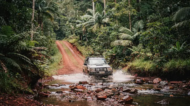
No. The Bloomfield Track is unsealed, crosses several creeks and the Bloomfield River, and requires a genuine high-clearance 4WD. Standard rental cars and caravans are excluded from it in almost every hire contract, and the track is frequently closed or impassable during the wet season.
A track, not a road: what the Bloomfield connects
North of Cape Tribulation, the sealed road ends. From there, the only way forward by land is the Bloomfield Track — an unsealed, 4WD-only route that climbs out of the Daintree lowlands, crosses the Bloomfield River near the Kuku Yalanji community of Wujal Wujal, and eventually rejoins sealed road on the approach to Cooktown. It is the sole overland link between the Cape Tribulation end of the Daintree Rainforest and Cooktown further north.
This is a different subject from the drive most visitors actually take. The sealed road from Cairns through Mossman to Cape Tribulation, including the Daintree River ferry crossing, is covered in driving to Cape Tribulation — that road is manageable in any rental car. This page is about what happens after the bitumen stops: the track itself, which vehicles can legally and practically use it, and when it simply isn’t passable at all. If you’re weighing a 4WD day tour from Cairns more broadly, including trips to Chillagoe or Undara that have nothing to do with the Daintree, see 4WD tours from Cairns instead.
Where the track starts and ends
The Bloomfield Track begins just north of Cow Bay and Thornton Beach, inside the northern reaches of the Daintree lowland rainforest, and runs for roughly 30 km before it meets sealed road again near Wujal Wujal. From Wujal Wujal, the route continues north through Ayton and on to Cooktown on a mix of gravel and sealed sections that are considerably less demanding than the track itself. Most people treat the true “Bloomfield Track” as the stretch between Cape Tribulation and the Bloomfield River crossing at Wujal Wujal — the part that is genuinely 4WD-only, creek-crossed, and weather-dependent.
It is worth being precise about this because a lot of general Far North Queensland guides blur the Bloomfield Track into “the road to Cooktown,” which makes it sound more casual than it is. The Cairns to Cooktown road trip itinerary lays out the full journey, including the option of avoiding the track altogether by taking the longer inland route via Mareeba and the Palmer Developmental Road, which is sealed the whole way and suits any vehicle. The Bloomfield Track is the shorter, harder, more scenic alternative — not the only way to get there.
Track conditions: what you’re actually driving on
The Bloomfield Track is unsealed for its entire length, with a surface that ranges from graded gravel to loose rock, deep ruts, and sections of red clay that become genuinely treacherous when wet. It climbs and descends steeply through rainforest terrain, with several tight, low-visibility bends. Along the way it crosses multiple creeks and the Bloomfield River itself, none of which are bridged in the conventional sense — most are causeways or fords that sit at or near water level.
That last point is the one to internalise: this is not a dirt road with the occasional puddle. Water depth at each crossing changes with rainfall upstream, sometimes within hours, and a crossing that was ankle-deep in the morning can be axle-deep or impassable by afternoon after a storm inland. Local advice in this part of Queensland is blunt for good reason — if a crossing looks flooded, you don’t guess, you turn around. This applies just as much on the Bloomfield Track as it does on any river crossing in the region; see seeing crocodiles safely for the reason those same crossings carry a second layer of risk beyond the water itself.
Which vehicles are actually allowed
This is the single most important practical fact about the Bloomfield Track, and it is where a surprising number of visitors come unstuck.
| Vehicle type | Allowed on the track? | Notes |
|---|---|---|
| Standard 2WD rental car | No | Excluded by essentially every rental agreement in the region |
| Standard “soft-roader” SUV (2WD or AWD, low clearance) | No | Ground clearance and lack of low-range make it unsuitable and usually excluded from hire contracts |
| Genuine 4WD with low range and high clearance | Yes, in dry conditions | The track is built for this class of vehicle, not for anything less |
| Rental 4WD from a company that explicitly permits it | Yes, if stated in writing | Not all 4WD rentals include Bloomfield Track access — check before you book |
| Caravan or camper trailer, any tow vehicle | No | Excluded outright; the track is not built for towing |
| Guided 4WD tour vehicle | Yes | The operator carries the risk and the local knowledge |
If your plan is to hire a car in Cairns or Port Douglas and drive yourself to Cape Tribulation and beyond, read your rental agreement’s exclusion list before you leave the counter. The Bloomfield Track is one of the most commonly named exclusions in Far North Queensland hire contracts, alongside similar unsealed routes further west. Driving an excluded vehicle onto the track doesn’t just risk getting stuck — it voids your insurance entirely, which turns a bogged car into a very expensive afternoon.
For a first visit, the practical answer for most travellers is either a proper 4WD hired specifically for the purpose, or a guided tour that includes the track as part of a longer Cape Tribulation or Cooktown itinerary — several of the wildlife and rainforest tours based around Cape Tribulation combine the sealed approach with side trips that give you a feel for the region without requiring you to self-drive the track at all.
a guided day tour from Cairns that covers Cape Tribulation with a local driver-guideWhen it closes: the wet season problem
The Bloomfield Track’s practicality swings hard between the two Far North Queensland seasons. In the dry season, roughly May to October, the track is usually in reasonable condition, the creek crossings run low and clear, and a well-prepared 4WD can cross without much drama. This is the only period most self-drive visitors should consider attempting it.
In the wet season, November to April, the picture changes completely. Rain across the Daintree hinterland raises every crossing on the track, sometimes to genuinely dangerous depths within an hour of a storm starting upstream. Local authorities close the track outright during and after heavy rain events, and it can stay closed, or open only to very high-clearance vehicles, for extended stretches during a wet cyclone season.
This is the same season that brings the region’s cyclone risk more broadly — see cyclone season: what to know for the wider picture, and Cairns in the wet season for what actually still works well during these months, because the wet season is not a write-off for the rest of the Daintree even when the track itself is off-limits.
The practical rule: never plan a Bloomfield Track crossing as a fixed appointment during the wet season. Build flexibility into any itinerary that includes it between November and April, and always check current road and closure status before leaving Cape Tribulation or Cooktown on the day. If in doubt, the sealed inland route to Cooktown via Mareeba remains open in conditions that shut the track completely, and it’s the fallback worth knowing about before you commit to the coastal option. For broader seasonal planning around the region, best time to visit Cairns covers how this affects a wider Far North Queensland trip.
What the drive is actually like
Assuming dry-season conditions and a suitable vehicle, the Bloomfield Track is one of the more rewarding short 4WD drives in Queensland, precisely because of what it passes through rather than despite it. The track runs beneath closed-canopy rainforest for much of its length, with glimpses down to the coast and out to the reef at a few clearings, and a detour to Bloomfield Falls near the river crossing is a common stop for those with time. The crossing at the Bloomfield River itself, close to Wujal Wujal, is the most talked-about section — wide, shallow in the dry season, and a reminder that you are in a saltwater crocodile habitat the entire time you are near it, whether you’re in the vehicle or out taking a photo.
Because the track passes directly through and beside Kuku Yalanji country, including the community of Wujal Wujal, it’s also worth treating the drive as a passage through inhabited land rather than an empty wilderness track — the same courtesy that applies to Mossman Gorge and the wider Kuku Yalanji Dreamtime Walk further south applies here too.
Allow two to three hours for the Cape Tribulation to Wujal Wujal stretch in good conditions, more if you stop at the falls or a lookout, and considerably more if the surface is wet or a crossing needs waiting out. This is not a drive to schedule tightly against a flight or a booked activity elsewhere.
Self-drive versus a guided 4WD tour
Self-driving the Bloomfield Track suits travellers who already have 4WD experience, a vehicle confirmed as permitted for the track, and enough slack in their schedule to turn back if a crossing looks wrong. It rewards that preparation with a genuinely independent, unhurried crossing at your own pace.
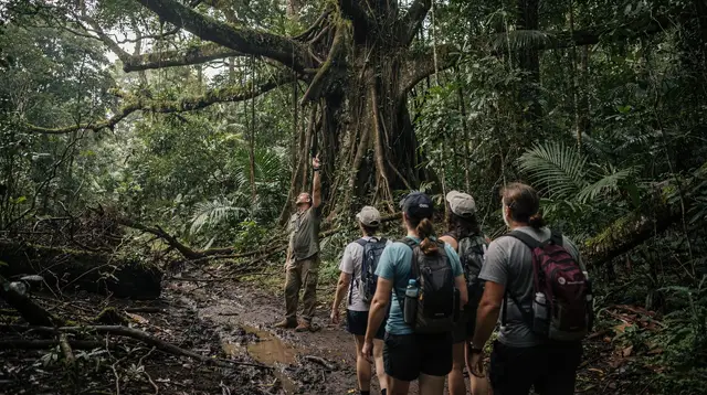
A guided tour is the better fit for almost everyone else, and it solves three problems at once: it removes the vehicle-eligibility question entirely, it puts local, current knowledge of the crossings in the driver’s seat, and it turns a technical drive into a rainforest and wildlife experience you can actually look up from. Several operators running longer Cape Tribulation and Daintree experiences fold a Bloomfield Track or Wujal Wujal component into multi-day itineraries, particularly those built around Kuku Yalanji culture and camping in the rainforest rather than a same-day return to Cairns.
a five-day guided glamping trip through Kuku Yalanji country that goes well beyond a single day’s drivingIf your interest in the area is really about seeing the rainforest and its wildlife rather than the driving challenge itself, a river cruise or night walk based around Cape Tribulation delivers most of what people are chasing on the Bloomfield Track — dense rainforest, the chance of a crocodile sighting, and a guide who knows exactly where to look — without needing a 4WD at all.
a guided night walk through the Cape Tribulation rainforest an adventure tour into the Daintree rainforest around Cassowary FallsFuel, supplies, and staying overnight
There is no reliable fuel available on the Bloomfield Track itself, and options thin out considerably once you’re past Cape Tribulation. Fill your tank fully before leaving Cape Tribulation, and again in Cooktown before heading back if you’re doing a return trip. Mobile phone coverage is patchy to nonexistent for long stretches of the track and the surrounding area, so treat this as a genuinely remote drive: tell someone your plan, carry water and basic recovery gear, and don’t rely on a phone signal to call for help if you get stuck at a crossing.
Because the crossing itself, the falls detour, and the drive to and from Wujal Wujal easily fill the better part of a day, many travellers choose to stay overnight in the Cape Tribulation area either side of the track rather than trying to combine it with a return drive to Cairns on the same day. Staying overnight in the Daintree covers what accommodation actually looks like north of the ferry, including the limited power and connectivity that come with staying this far off the grid.
Combining the track with the rest of the Daintree
For travellers who do make the crossing, it’s worth pairing the Bloomfield Track with the parts of the northern Daintree that are easy to miss on a standard day trip south of Cape Tribulation. A wildlife cruise on the Daintree River, whether taken before heading north or on the way back through, is the most reliable way to actually see a saltwater crocodile in the wild rather than simply respecting the risk of one at a creek crossing.
a guided wildlife cruise on the Daintree River
If you’re deciding how the Daintree fits against the region’s other rainforest experience around Kuranda, Daintree versus Kuranda rainforest lays out how the two compare for travellers who can only fit one properly into their trip. And if Cooktown itself, rather than the track, is the actual destination, Cooktown and the Far North picks up from where this guide leaves off, at the Endeavour’s landing site and the town James Cook and his crew spent 48 days repairing their ship in 1770.
The bottom line
The Bloomfield Track is a genuine 4WD track, not a scenic back road: unsealed, creek-crossed, closed outright during heavy wet-season rain, and off-limits to standard rental cars and anything you’re towing. Treat it that way — right vehicle, dry-season timing, fuel topped up, and a willingness to turn back at a crossing that doesn’t look right — and it’s one of the more memorable short drives in tropical Australia. Treat it as just another road north, and it’s the kind of mistake that ends a Far North Queensland trip early.
4WD and outback tours on GetYourGuide
Verified deep-linked GetYourGuide tours. Book through these links and we earn a small commission at no cost to you.
GetYourGuide does not provide a product photo for this activity — the image shows the meeting point, photographed by us.