Where the outback route begins
Most visitors to Cairns never get further inland than the Atherton Tablelands, and for a normal holiday that is entirely reasonable — the reef and the rainforest are both within an hour or two of the coast. The Savannah Way is a different kind of trip.
It is a signed, cross-continental route that starts in the Cairns region and runs west across the savanna country of Far North Queensland, through the Gulf Savannah, and eventually all the way to the Kimberley in Western Australia if you keep going long enough. Most people who tackle it from Cairns are not doing the whole continent — they are doing the Queensland leg, from the coast to the Gulf of Carpentaria at Karumba, with Undara as the first real stop.
This page is here to set expectations, not to repeat what is already covered in detail elsewhere. If you want the lava tubes explained properly, that is the Undara lava tubes guide. If you want the limestone caves at Chillagoe covered in full, that is the Chillagoe caves day trip guide. What belongs here is the shape of the route itself: how it starts, how far it goes, what condition the road is in, and — the single most important thing to get right before you commit a week to it — how it is genuinely not something you can bolt onto a normal Cairns itinerary as a day excursion.
The one mistake to avoid: this is not a day trip
It is worth saying plainly, because a lot of trip-planning software and generic itinerary lists blur it: the Savannah Way is not a day trip from Cairns, and neither is Undara on its own. Undara sits about 275 km from Cairns by road, which on the inland highway is roughly three and a half hours of driving each way. Do the arithmetic and a same-day return means seven hours behind the wheel for a few hours on the ground — before you have even looked at a lava tube. Tour operators and independent travellers alike treat Undara as an overnight minimum: drive out, tour the tubes and stay at the lava tube lodge or camp, then either return to Cairns the next day or keep heading west.
And Undara is only the first waypoint. The Savannah Way proper continues well beyond it — through Georgetown, Croydon, and out to Normanton and Karumba on the Gulf, several hundred kilometres further into increasingly remote country. Treating any part of this as a quick loop out of Cairns undersells both the distances involved and the character of the trip, which is really about slow travel through the outback, not a checklist stop.
What the route actually looks like
From Cairns, the Savannah Way is usually picked up via the Gillies Highway or the Kennedy Highway, climbing onto the Atherton Tablelands before dropping down the range and out onto the drier inland plains around Mareeba and Mount Garnet. This transition is itself part of the experience — the humid, green Tablelands give way within an hour or two to red dirt, spinifex, and the flat horizon line of savanna country. It is a genuinely different Australia from the coastal strip most Cairns visitors see, and that contrast is a large part of why people make the trip.
| Leg | Approx. distance from Cairns | Typical stop |
|---|---|---|
| Cairns to Undara | ~275 km | Lava tube tours, overnight |
| Cairns to Chillagoe | ~200 km (different road, north of Undara) | Limestone caves, overnight |
| Undara to Georgetown | ~150 km | Fuel, gemfields access |
| Georgetown to Normanton | ~280 km | Historic rail town, Gulf approach |
| Normanton to Karumba | ~70 km | Gulf of Carpentaria, fishing base |
Note that Undara and Chillagoe sit on different roads out of the Cairns region rather than on the same line of travel — they are both “outback day-and-a-half” destinations, but you would not usually combine them on a single pass unless you are looping back through the Tablelands between them. Cooktown, further north again, is reached via a completely separate route up the coast or via the Cape York developmental road, not via the Savannah Way corridor at all — see the Cooktown and the far north guide for that leg.
Undara: the closest and most manageable stop
For most Cairns-based travellers who want a taste of the Savannah Way without committing to the full run to the Gulf, Undara is the answer. It sits close enough to the coast to be reachable in half a day’s drive, has organised accommodation and guided tours, and delivers a genuinely spectacular natural feature — ancient lava tubes formed by one of the longest known lava flows from a single volcano on Earth. The detail on what the tubes are, how the tours run, and what to bring belongs in the Undara lava tubes guide; the point to make here is that Undara functions as both a standalone overnight destination and as the natural first leg of the longer Savannah Way for those who want to keep going.
Anyone weighing up whether to base an outback side trip around Undara or Chillagoe should read both destination guides, but as a rule of thumb: Undara suits travellers who want lava tubes and a lodge-style overnight experience, while Chillagoe suits those drawn to limestone cave systems and a slightly more remote, self-sufficient feel. Both are reachable from Cairns without needing to continue on to the Gulf.
Continuing west: Georgetown, Croydon, Normanton
Past Undara, the Savannah Way settles into its long-haul character. Georgetown is a small service town with fuel, basic supplies, and access to the historic Etheridge gemfields, where fossicking for topaz is a popular stop for those with time to spare. Croydon, further on, was once a serious gold-mining town with a population in the thousands during the 1880s boom; today it is a quiet outback settlement with restored heritage buildings that hint at what it used to be.
Normanton, close to the Gulf, is home to the restored Burns Philp building and the Gulflander railway, one of Australia’s most isolated rail lines, along with a life-size replica of “Krys,” a 8.63 m saltwater crocodile shot nearby in 1957 — a reminder, even out here, that crocodile country extends well beyond the coastal rivers around Cairns.
Karumba and the Gulf of Carpentaria
Karumba is the end of the road for most Savannah Way travellers heading west from Cairns — a small town on the Gulf of Carpentaria built around commercial fishing and, increasingly, recreational barramundi fishing. It has one of the few spots in the country where you can genuinely watch the sun set over water on the west coast of a state that otherwise faces east, since the Gulf coastline here runs the “wrong” way.
Fishing charters, prawning boats, and a slower, tide-driven pace of life define the town. For travellers who have spent a week getting here, Karumba functions as both a destination and a natural turnaround point before the long drive back to the coast — or, for the more ambitious, the springboard to continue the Savannah Way onward toward the Northern Territory.
Road conditions and when to go
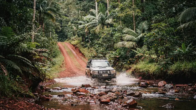
The dry season, roughly May to October, is the only realistic window for this route. Outside that window, sections of the Savannah Way — particularly the unsealed stretches west of Georgetown and around the Gulf — can flood or become badly corrugated, and some roads are impassable to conventional vehicles after heavy rain. Queensland’s own advice on flooded roads applies here as everywhere: if it’s flooded, forget it.
Even in the dry season, expect long unsealed sections, limited fuel stops, and patchy or absent mobile coverage once you are well past Undara. A conventional car can usually manage the sealed sections as far as Undara and Chillagoe, but a high-clearance vehicle is strongly preferable for the unsealed stretches further west, and essential if you plan to detour off the main route.
Fuel and supplies should be topped up at every opportunity rather than assumed — Georgetown, Croydon, and Normanton are the main service points, and the gaps between them are long enough that running low is a real risk, not a theoretical one. Carry extra water, tell someone your route and expected arrival, and check road condition reports before setting out, especially in the shoulder months either side of the dry season.
What to plan before and after
Because this is a route rather than a single attraction, it works best as a dedicated chapter of a longer Tropical North Queensland trip rather than something squeezed in alongside reef and rainforest days. Travellers building a full itinerary might read how many days in Cairns to figure out how much time the coast alone deserves, then treat the Savannah Way as additional days tacked onto the end, ideally with a car already suited to gravel roads.
Those who prefer a shorter taste of the outback without leaving the coastal loop should look at the Cairns to Cooktown road trip itinerary instead, which covers similarly remote-feeling country on a different, more accessible road.
Before setting off, it is worth booking any reef time first — a morning on the water is easier to arrange around a fixed departure date than an open-ended outback drive. Options like the Quicksilver Outer Barrier Reef Cruise or a day of certified diving through the Day Trip Certified Diving from Cairns pair naturally with a coastal stay before you turn the car inland.
For those wanting a taste of the Tablelands’ greener side before the savanna’s dry heat, the Original Paronella Park Lake Barrine Millaa Millaa tour covers some of the same territory you will drive through on the way to Undara, minus the overnight commitment.
Savannah Way: frequently asked questions
Is the Savannah Way a day trip from Cairns?
No. Undara alone is about 275 km from Cairns, roughly three and a half hours each way, and is treated as an overnight minimum by both tour operators and independent drivers. The full Savannah Way continues far beyond Undara to Karumba on the Gulf of Carpentaria, making the complete route a multi-day undertaking, not a single-day excursion.
How long does the full Savannah Way from Cairns to Karumba take?
Most travellers allow five to seven days for the Queensland leg from the Cairns region to Karumba, including stops at Undara, Georgetown, Croydon, and Normanton. Rushing it defeats the purpose, since much of the appeal is the slow change in landscape and the small outback towns along the way.
Do I need a 4WD for the Savannah Way?
A conventional vehicle can usually handle the sealed roads as far as Undara and Chillagoe. Beyond Georgetown, unsealed sections become more common, and a high-clearance or 4WD vehicle is strongly recommended, especially outside the core dry season months or if you plan any side detours.
What is the best time of year to drive the Savannah Way?
May to October, the dry season, is the only reliable window. Outside these months, unsealed sections can flood or become impassable, and the advice for any flooded road in this region is simple: if it’s flooded, forget it.
Are Undara and Chillagoe on the same route?
No. They sit on different roads out of the Cairns region and are usually visited as separate overnight side trips rather than combined on one continuous drive, unless you loop back through the Atherton Tablelands between them.
Is Cooktown part of the Savannah Way?
No. Cooktown is reached via a separate coastal or Cape York route, not via the Savannah Way corridor, even though both are considered part of the wider Far North Queensland outback experience.
What is at the end of the Savannah Way in Karumba?
Karumba is a small Gulf of Carpentaria town built around commercial and recreational fishing, particularly barramundi. It also offers a rare west-facing sunset over water, since the Gulf coastline runs opposite to Queensland’s east coast.
What should I check before setting out?
Fuel and water levels, current road condition reports, and the weather forecast for the days ahead. Fuel stops are limited to a handful of towns along the route, and mobile coverage largely disappears west of Undara.